This is
Hyde Daily Photo Volume 1 (2006-2011) which is now in archive mode. For recent photographs please visit
Hyde Daily Photo Volume 2. Additional material and links to blogger friends can be found at
Hyde DP Xtra.

Now housing a sheet-metal factory, in 1877 this building on the corner of Henry Street and Edna Street was originally Hyde Grammar School.

The end of Apethorn Farm is it abutts on to Apethorn Lane.
Originally a cruck-framed longhouse from the 15th century, it was encased in rubble in the 17th century and later with brick.
The scene of a murder in 1831, it was divided into cottages in 1928 but in 1993 a fire reduced to it to just the original cruck frame.
There is a pre-1920s photo on
Old Hyde and also a photograph from
May 2000.

Last month I showed you a glimpse of the
Rising Moon.
Here now is a fuller view of the front of the pub.

Even in the rain, the carousel on Hyde Market is a popular attraction. It has been operated by the same family for around a hundred years!

Sunday afternoon in Hyde Market Place is a quiet time with most of the shops shut, but it isn't entirely deserted unlike the old Woolworths' building which is awaiting new occupants.

After the complicated
pipework near the textile mills, Godley Brook continues its journey.
Regular readers will be aware that I've moved recently. It took a few weeks to get the phone line installed and some days more before my internet connection was restored.
Meanwhile Rune with assistance from Tom have kept things moving along on a daily basis and I owe them tremendous thanks. I've been peeking in from time to time, via library access and have enjoyed reading the lovely comments on the posts.
It will take me some time to get up to steam and visit other blogs, but like the little river, I'm flowing again.
Tom of
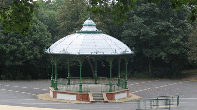
Wiggers World has today supplied us with the following photo and accompanying text from Hyde:
Over the last few years more than £2m has been spent bringing Hyde Park into the 21st century, Hyde Park dates back to the beginning of the 19th century. It was built by a local mill owning Ashton family, who offered the estate to Hyde Corporation in 1897.
Thank you, Tom!
RuneE - temporary caretaker.

Keystone of the
Hearse House belonging to St Georges Church.
Gerald is still waiting for his ISP and British Telecom to sort out his connection to the Internet. In the meantime, Tom of
Wiggers World has kindly supplied this post from Hyde.
RuneE - temporary caretaker.

Some of you may know that Gerald has been moving house lately. I can report that the move has been successful - with one exception: His phone is up but his Internet-connection is still down. However, he hopes that this will be remedied soon, and that he will be back on-line in the near future.
In the meantime you can enjoy this old stone pathway that leads up from the
River Tame to the
Peak Forest Canal, voted
his best photo in 2008 by his loyal readers.
RuneE - temporary caretaker

If you leave the
TransPennine Trail near the entrance to
Gower Hey Wood but in the opposite direction, you come to a grassy triangular area leading to Dowson Road.
It was back in October 2006 that I reported on the
demolition of the car showrooms that were on the site of
Cockshoots Garage.
In its place has been built a block of retirement apartments known as Enfield Court after
Henry Enfield Dowson.

Last August I showed you one of the entrances to
Gower Hey Wood.
Go over the style and you will find steps leading down into the valley and duck boards laid across the muddy bottom.

Further on you meet Gower Hey Brook.
A network of footpaths will take you in various directions.

Looking down Acorn Avenue towards Hyde Chapel.

Motorists coming off the M67 at
junction 3 are greeted by a plethora of road signs.
So where do you want to go?

Built in 1889 as Enfield Street School, this building on the corner of
Knott Lane is now a residential care home.
Some weeks ago I showed you a slightly more
distant view.

Some weeks ago I showed you the
Steps to the Grange.
This is the footpath in the opposite direction from the end of Hinton Grove.
On the left hand side is the valley of the infant Werneth Brook, whilst above the banking on the right lie the playing fields of Alder School.
Around the corner are those steps.

This is the ramp on the South side of the M67 leading to a footbridge over the motorway.
On the other side, descent is via a
spiral ramp.

As the plaque on the middle of this row of terraced cottages on Mottram Old Road states, these houses date from 1838.
At least two of them have had not so much a simple "loft conversion" as a "loft extention".

Back in July 2008 I showed you the construction site on
King Edward Avenue as viewed from the top of Treacle Brow.
Just look what's there now.

Here now are the last three day's views combined together.
Compare it with the view some ten minutes earlier from the
bridge over the canal.

Yesterday I showed you the top of the 1828 warehouse.
Today, here is the bottom part reflected in the canal.

A view from the same place as yesterday's photograph but looking across the canal to the grade II listed
canal warehouse, dating from 1828.

Remember my recent photograph of the canal from the
Manchester Road Bridge?
This was taken about some ten minutes later from the towpath under the bridge.

Last week I asked you where/what this was. Now I can reveal that it is the beginning of the spiral ramp on the North side of the M67 near Morrisions, leading to a footbridge over the motorway.
I first featured this in a post from
June 2007.

As I related in my post of
17th January 2009 close views of Hyde Chapel are extremely difficult to achieve as in summer the trees shield it and in winter the sun is low.
However, the leaves haven't begun to appear just yet, so a few weeks ago I managed to secure this image from the corner of School Lane and Stockport Road.

The last time I showed you the Grapes Hotel in
July 2008 it was covered in scaffolding.
See how it looked in
2007, back in
2003 or way back around
1910.
Now that it has a new restaurant attatched it appears to have dropped "Hotel" from its name and become simply "The Grapes".

Post Office?
Well it was at one time. It closed about three years ago despite local protests and the farce of a so-called "consultation document" as inevitably the talk was one way only.
I don't know its history but the brickwork seems to tell a tale. The side wall clearly indicates the previous presence of a fire and a chimney. The absence of a chimney pot on the roof makes me suspect that the fire was removed at the time when the front room was converted for use as a Post Office.
There were always living quarters behind and above the P.O. By the time it reverted to a residence again, doubtless central heating obviated the need for a flued fireplace.
Across the road is
Sweetie Corner.

This is the junction in Gee Cross where Stockport Road veers to the left down into Hyde. The A560 carries on as Mottram Old Road past the
1823 cottages.
In the 1920s there were houses still in the area behind the signpost and tramlines ran the length of Stockport Road. See this view on
Old Hyde.
Unless otherwise stated, all photographs on this site are copyright © 2006, 2007, 2008, 2009, 2010, 2011 Gerald England.
In most cases, clicking on the photograph will reveal a larger-sized image.


 Tom of Wiggers World has today supplied us with the following photo and accompanying text from Hyde:
 Keystone of the Hearse House belonging to St Georges Church.