This is
Hyde Daily Photo Volume 1 (2006-2011) which is now in archive mode. For recent photographs please visit
Hyde Daily Photo Volume 2. Additional material and links to blogger friends can be found at
Hyde DP Xtra.

Recently I showed you
St Stephen's Steeple on
Bennett Street.
Trees and angles make it difficult to take a photograph the whole church, but as this is the last day of the month, I thought I'd try and squeeze it all in.

When I showed the
Stonecraft car dealership a few weeks ago, someone asked
However do they get the cars out of that narrow lot?
Well the answer is that most of the cars are parked in a second lot across the road.
Dawson Street leads into an area marked on google-maps as
Redfern Industrial Estate, which is actually just a collection of small industrial units. I'm not sure all the units are occupied nor what kinds of work takes place there.

These are the sluice gates at Godley Reservoir.
Of the two pylons you can see, I'm not sure which is the one featured here
last Monday.

A couple of bikers just below the kissing gate on
Higham Lane.

This is known as a
mini-roundabout.
Traffic is supposed to go around it, but they are built so that large vehicles can drive over them.
This one is in the Flowery Field area of town.

Jefferson's cheese stall in the indoor market is no more. The couple have retired.
However, Kelly has taken over the space with her authentic Indian cuisine. The produce is all home-made and you can sample her wares before you buy.
She can also be found in Mossley and at the Farmer's Market in Ashton.

Close to Aspen Wood in Godley.

A couple of weeks ago I showed a picture of
St Mary's church in Newton.
That was a view from the West; this is from the North.

Last week I posted the
November Quiz and asked - what is on the warning notice up the tree?
There were some great answers given. I especially liked
Marley and
Hilda's idea of trolls living under the bridge.
Mandy came closest with "take your litter home" but the true answer is
No Dog Fouling
Poop and Scoop area
An uncropped version showing the lane, the tree, the sign and the tunnel under the M67 motorway can be seen on the
Geograph site.

Today's photograph is a contribution to
Skywatch Friday.
Horse-riding is a popular pastime in the countryside around Hyde and there are a number of very pleasant bridleways.
This one leads from near the cricket ground at Godley towards Barmhouse Lane. On the left hand side in the valley is the M67 motorway and on the right hand side is the water treatment works and Godley Reservoir.

Some time ago I showed a photograph of the
Bandstand in Hyde Park.
Here now is a closer look at the artwork around the columns.

The finger-post at this kissing-gate on Higham Lane indicates that is half a mile to Gee Cross.

This Manchester-bound train is pulling into
Broadbottom Station.
Reflected in the windows are the
lines of the cross-platform bridge.
You can see a Glossop-bound train at Broadbottom Station in July 1988 on
Old Hyde.

This is the Western end of Bennett Street.
Here a narrow bridge crosses the railway line between
Hyde Central and
Hyde North at an angle. A separate footbridge runs alongside it.
Beyond the bridge the road changes its name to Lower Bennett Street, meets Dukinfield Road opposite
Newton Hall, then continues as Dunkirk Lane which leads to
Dunkirk Farm.

When I showed the entrance to this
Horse and Cycle Track earlier, someone commented
Difficult "cohabitation" between bike and horse drivers usually
and I couldn't agree more.

It is time for another quiz.
This month I don't want you to tell me where this is.
Do you see the tree on the right-hand side by the fence?
There is a warning notice in the tree (I've cropped the picture so it is out of view).
The question is - what is on the warning notice up the tree?
As usual, prizes at my discretion for correct or witty answers, and the solution will be revealed next week.

There are autumn leaves everywhere and not least on this footpath leading from Mottram Road down into Godley Vale.

The New Inn on the A57 at Hattersley.
How new?
Well I'm told it dates back to the 1600s and was known as a highwayman's inn. There are tales of it being haunted by a ghost named Mary.
In the background is Wardlebrook Avenue on Hattersley. The house where Ian and Myra did their nefarious deeds has thankfully been long demolished.
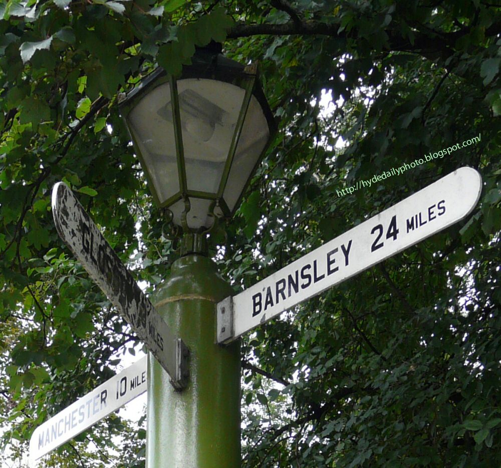
This old signpost and lamp near the
Gun Inn at Hollingworth is somewhat obscured by the tree behind it.
The lamp was probably originally lit by gas but is now electric.
Barnsley is 24 miles distant on the A628 over Woodhead, Manchester is 10 miles West along the A57 and Glossop is just 3 miles away.

The eleventh day of the eleventh month is Remembrance Day so I thought an appropriate post would be a close-up view of the War Memorial on
Mottram Road, Broadbottom.
It is a four-sided edifice, with pillars at each corner. The pillars are capped with pinnacles and the monument topped with a dome bearing a large cross.
The inscriptions are bourne on four marble slabs, above each of which is a small gable.
Even though still to be completed, it was unveiled on Saturday, July 1, 1922.

The next few days photos are scheduled as I'm on an alternative course myself having gone for a bit of fresh sea air in Blackpool. I just hope it isn't
too fresh.
In my absence,
Per Strömsjö from Stockholm will be minding my blogs.
See you all again at the end of the week.

St Mary's Church, Newton.
This is the Western aspect taken from within the graveyard.

A couple of weeks ago I reported that
Automasters is Gone.
The bulldozers have moved in and are clearing the site.
For the time being at least, it opens up the area somewhat for walkers on the towpath.
That was the scene about three weeks ago - even that has gone now as can be seen from the photograph I took yesterday and posted on
Geograph.

I reported earlier about the plans by Ricky Hatton to turn the old
printworks into a gymnasium.
Work seems to have started on the transformation of the building. Meanwhile I thought some readers might like to see a closer version of the poster displayed on the building.

The view looking down Joel Lane from the top on
Werneth Low Road.
See the view in the opposite direction about 100 years ago on
Old Hyde.

Rain on the pavement by the pedestrianised part of the Market Place.
O and some more bollards.

This War Memorial lies at the fork in the road where Cartwright Street leaves Victoria Street.
The memorial, unveiled on 13th March 1920, is 12ft high with the bottom base 4ft square. It rises in three successive diminishing bases on which is a large die surmounted by a cap on which stands the figure of a soldier symbolising the brave fellows to whom the memorial is erected.
A new bronze statue of a soldier was erected in 2005.

Our contribution on the first Monday of the month to
Broer som Binder [Bridges between] is a follow up to last month's post of two
Side by Side bridges.
Today we are looking between them at the River Etherow flowing below.
More details of and links to other participants to
Broer som Binder can be found on
Visual Norway.

Two weeks ago I showed you the
South Window of St Thomas the Apostle.
Like the other windows, the designs all belong to
William Morris.
This figure of
St Thomas first appeared in 1874 in Calcutta Cathedral where it faces left. Here it faces right.
The figure of
St Hilda was originally used at Paisley Abbey in 1876 to represent
Salome. Only in Hyde has it been modified by the addition of a pastoral staff.
 Barclay's Bank
 is on Market Street.
Originally this was a branch of
Martin's and if you look closely (click on the photo to enlarge) the old shield logo can just be made out on the marble facade.
Martin's was absorbed into
Barclay's forty years ago.
Another interesting feature in this photograph is the road sign. For the M67 West to Manchester or Stockport, you turn left (West) and then right at
the sliproad. For Sheffield and the M67 East though you have turn West. After that you need to turn right at the Red Lion and double-back along Clark Way over the motorway.
If I was going to Sheffield from Hyde, I wouldn't start from here.
Unless otherwise stated, all photographs on this site are copyright © 2006, 2007, 2008, 2009, 2010, 2011 Gerald England.
In most cases, clicking on the photograph will reveal a larger-sized image.